| STATISTICS |

Total online: 1 Guests: 1 Users: 0 |
|
Главная » 2011 » December » 23
 Hexagram is the most ancient mathematical symbol, known to mankind throughout millennia. It is considered that this international symbo has been found for the first time in India where it was used before has appeared in Europe and in the near east. By the legend hexagram has been represented on shields of tsar David soldiers and on the seal of Solomon. The symbol of hexagram meets at many people, on different continents and always mystical sense is put in it allocating with magic properties. READ MORE Hexagram is the most ancient mathematical symbol, known to mankind throughout millennia. It is considered that this international symbo has been found for the first time in India where it was used before has appeared in Europe and in the near east. By the legend hexagram has been represented on shields of tsar David soldiers and on the seal of Solomon. The symbol of hexagram meets at many people, on different continents and always mystical sense is put in it allocating with magic properties. READ MORE
Views: 666 |
Added by: GeoLines |
Date: 23.12.2011
|
|
 For nearly a century, archeologists have routinely used aerial photo-graphs as a key tool for discoveries and investigations. In western Europe, the discovery through aerial reconnaissance oftens of thousands of previously unknown sites has transformed the way the past is interpreted and explained. In discussions of archeology, aerial views are often far more informative than ground photographs because the aerial views show the whole site within its geographical and environmental context, and they often show patterns too subtle or confusing to be recognizable on the ground.
In the Middle East as a whole, there is a growing awareness of the value of this
...
Read more » For nearly a century, archeologists have routinely used aerial photo-graphs as a key tool for discoveries and investigations. In western Europe, the discovery through aerial reconnaissance oftens of thousands of previously unknown sites has transformed the way the past is interpreted and explained. In discussions of archeology, aerial views are often far more informative than ground photographs because the aerial views show the whole site within its geographical and environmental context, and they often show patterns too subtle or confusing to be recognizable on the ground.
In the Middle East as a whole, there is a growing awareness of the value of this
...
Read more »
Views: 588 |
Added by: GeoLines |
Date: 23.12.2011
|
|
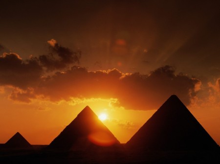 Everybody know about the Egyptian pyramids. And everyone is familiar with the official version of their origin: pyramids are constructed with exploitation of thousand slaves. But, always were skeptics who subjected this version to doubt. In that sense illiterate slaves could not construct so grandiose objects. Then who then? When there is no convincing hypotheses imagination comes. As authors of pyramids considered inhabitants of Atlantis or aliens. But many people having heard about these versions preferred to trust in slaves and Pharaohs further .But questions remain
...
Read more » Everybody know about the Egyptian pyramids. And everyone is familiar with the official version of their origin: pyramids are constructed with exploitation of thousand slaves. But, always were skeptics who subjected this version to doubt. In that sense illiterate slaves could not construct so grandiose objects. Then who then? When there is no convincing hypotheses imagination comes. As authors of pyramids considered inhabitants of Atlantis or aliens. But many people having heard about these versions preferred to trust in slaves and Pharaohs further .But questions remain
...
Read more »
Views: 584 |
Added by: GeoLines |
Date: 23.12.2011
|
|
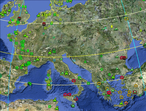 The site has got a new section - INTERACTIVE MAPS
This section contains maps visually displaying information associated with a variety of historic sites. Now you can see where exactly is he a historical object, determine its location relative to other objects and make a click to get full information about it. Nazca geoglyphs 3D map allows to consider them in their entirety and to assess the true extent of this phenomenon. To view the maps on your computer must have a Google Earth plug-in. It could be d
...
Read more »
Views: 596 |
Added by: GeoLines |
Date: 23.12.2011
|
|
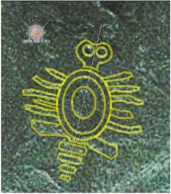
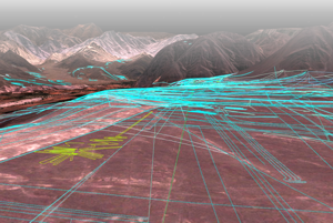 As a result of the majority portrayal of visible on space pictures lines and figures on Naska plateau has appeared possibility of geoglives researches in their aggregate. The majority of interesting moments have come at once to light allowing to tell about Naska lines as about the certain uniform system which comprises the certain sense. Probably those laws will designate the way which will approach us to understanding of device system principle and finally will lead us to perusal of the information put into it... READ MORE As a result of the majority portrayal of visible on space pictures lines and figures on Naska plateau has appeared possibility of geoglives researches in their aggregate. The majority of interesting moments have come at once to light allowing to tell about Naska lines as about the certain uniform system which comprises the certain sense. Probably those laws will designate the way which will approach us to understanding of device system principle and finally will lead us to perusal of the information put into it... READ MORE
Views: 581 |
Added by: GeoLines |
Date: 23.12.2011
|
|
 The well-known figure of nine paw monkey, geoglyph in desert Naska, is a riddle for science and a masterpiece of ancient art. Drawing to create which is difficult enough, represents difficultly solvable puzzle. The well-known figure of nine paw monkey, geoglyph in desert Naska, is a riddle for science and a masterpiece of ancient art. Drawing to create which is difficult enough, represents difficultly solvable puzzle.
Simple and elegant geometrical decisions, are imperceptible at first sight, simply because drawing consists of two components combined in the general design, and it is perceived, as a single whole. The first part is a pentagram precisely given with drawing lines, the second is squares in which all image is entered. A square influences to all structure of drawing, and its party precisely are orientated on parts of the world.
...
Read more »
Views: 585 |
Added by: GeoLines |
Date: 23.12.2011
|
|
 In the beginning of March server Google Earth has updated space pictures in the program with the same name. In higher resolution some areas around Naska desert became accessible also. On Palpa plateau now it is possible to examine well images of humanoid figures and accordingly to define their exact position relatively to other elements and in a southern part of Naska plateau were found geoglives unknown earlier, at least, data about them still are not found. In the beginning of March server Google Earth has updated space pictures in the program with the same name. In higher resolution some areas around Naska desert became accessible also. On Palpa plateau now it is possible to examine well images of humanoid figures and accordingly to define their exact position relatively to other elements and in a southern part of Naska plateau were found geoglives unknown earlier, at least, data about them still are not found.
READ MORE ....
Views: 630 |
Added by: GeoLines |
Date: 23.12.2011
|
|
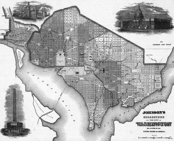
When the site for Washington D.C. was chosen to be the national capital of the United States, it was an undeveloped area. George Washington selected Pierre L'enfant to design the layout of the city. George Washington was the highest ranking member of the Masons at the time and the Masons were ardent students of ancient civilizations such as those of the ancient Egyptians and Greeks. This is evidenced by many of the monuments in and around the city. It has also been suggested that the streets, the broad diagonal avenues, and the blocks and circles left open for monumental structures, incorporated geometric designs of Masonic relevance, as shown in the 1862 map of Washington D.C. pictured below.
Views: 545 |
Added by: GeoLines |
Date: 23.12.2011
|
|
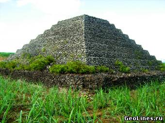 It appears, pyramids there are even on island Mauritius which is in Indian ocean, almost one thousand kilometres to the east from Madagascar. The most nteresting in these pyramids that they are located on a small islet of volcanic origin mislaid in the boundless ocean spaces but that they are almost exact copy of Guimar Pyramids,which are placed with another side of Africa, on an island Tenerife. Pyramids are very similar both outwardly and by manufacturing way and it gives al
...
Read more » It appears, pyramids there are even on island Mauritius which is in Indian ocean, almost one thousand kilometres to the east from Madagascar. The most nteresting in these pyramids that they are located on a small islet of volcanic origin mislaid in the boundless ocean spaces but that they are almost exact copy of Guimar Pyramids,which are placed with another side of Africa, on an island Tenerife. Pyramids are very similar both outwardly and by manufacturing way and it gives al
...
Read more »
Views: 629 |
Added by: GeoLines |
Date: 23.12.2011
|
|
In section ONWARD TO THE PASTchapter from the book of Helium Kleymenov Nibiriada is published. A part 4 Building of millennia. In this fragment the author shows impossibility of the Great pyramid erection by ancient Egyptians.
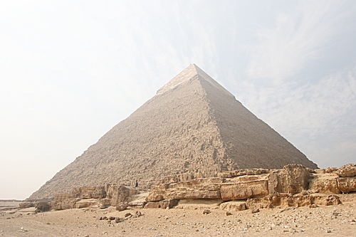 Hopeless attempts continue somehow to explain the fact of existence of Giza pyramids complex without involving extraterrestrial reason, and being based only on human race possibilities, but the more attempts of substantiation of such point of view are the more noticeable principle impossibility of similar building by forces of p
...
Read more » Hopeless attempts continue somehow to explain the fact of existence of Giza pyramids complex without involving extraterrestrial reason, and being based only on human race possibilities, but the more attempts of substantiation of such point of view are the more noticeable principle impossibility of similar building by forces of p
...
Read more »
Views: 606 |
Added by: GeoLines |
Date: 23.12.2011
|
|
Views: 506 |
Added by: GeoLines |
Date: 23.12.2011
|
|
|
|
|
| 3D MAPS |
 |
| CINEMA |
 |
| CALENDAR |
| « December 2011 » | | Su | Mo | Tu | We | Th | Fr | Sa | | | | | | 1 | 2 | 3 | | 4 | 5 | 6 | 7 | 8 | 9 | 10 | | 11 | 12 | 13 | 14 | 15 | 16 | 17 | | 18 | 19 | 20 | 21 | 22 | 23 | 24 | | 25 | 26 | 27 | 28 | 29 | 30 | 31 |
|
|